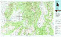
1980 Map of Beaver
USGS Topo · Published 1995About this map
Beaver sits as the central hub of this high-altitude landscape, where the Beaver River descends from the Tushar Mountains toward the Escalante Desert. Compiled from surveys as early as 1953 and updated through 1980, the map illustrates a region defined by its proximity to the Fishlake National Forest and Dixie National Forest. Agricultural patterns are evident along the Greenville Bench and Manderfield Bench, while industrial interests are marked by several workings in the Mineral Mountains, including the Fortuna Mine and Beaver View Mine.
Find a feature on this map
75 named features on this map. Tap any name to fly to it.
Don’t see what you’re looking for? This feature index may not catch every label — zoom into the map to look around manually.
Map Details
Editions of this 1980 Beaver Map
2 editions found
Other maps of this area

1885 · St. George
USGS Topo · 1:250,000

1885 · Beaver
USGS Topo · 1:250,000

1885 · Fish Lake
USGS Topo · 1:250,000

1886 · Kanab
USGS Topo · 1:250,000

1886 · Escalante
USGS Topo · 1:250,000

1891 · St. George
USGS Topo · 1:250,000

1896 · Fish Lake
USGS Topo · 1:250,000

1932 · Sevier
USGS Topo · 1:62,500

1935 · Sevier
USGS Topo · 1:62,500

1937 · Delano Peak
USGS Topo · 1:48,000