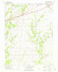
1974 Map of Beaver Creek
USGS Topo · Published 1977About this map
Beaver Creek (Wisetown) and the surrounding agricultural townships of Burg and Mills define this southern Illinois landscape during the mid-1970s. The map illustrates a transition in local infrastructure, where the Penn Central rail line cuts across the northern territory through the community of Stubblefield, while the Old Ripley Grade Railroad appears elsewhere. Evidence of the region's energy and transportation development is visible in the Stubblefield Storage Gas Field and the Greenville Municipal Airport near the northeastern corner.
Find a feature on this map
22 named features on this map. Tap any name to fly to it.
Don’t see what you’re looking for? This feature index may not catch every label — zoom into the map to look around manually.
Map Details
Editions of this 1974 Beaver Creek Map
This is the sole edition of this map. No revisions or reprints were ever made.
Other maps of this area

1906 · Breese
USGS Topo · 1:62,500

1907 · Breese
USGS Topo · 1:62,500

1910 · Carlyle
USGS Topo · 1:62,500

1932 · Greenville
USGS Topo · 1:62,500

1937 · New Douglas
USGS Topo · 1:48,000

1939 · Greenville
USGS Topo · 1:62,500

1943 · Greenville
USGS Topo · 1:62,500

1944 · New Douglas
USGS Topo · 1:62,500

1948 · Carlyle
USGS Topo · 1:62,500

1958 · Belleville
USGS Topo · 1:250,000