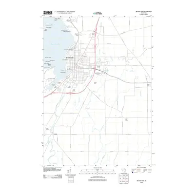
2010 Map of Beaver Dam
USGS Topo · Published 2010About this map
Beaver Dam serves as the focal point of this Dodge County landscape, situated along the southeastern shores of Beaver Dam Lake. The map reveals a high concentration of ecclesiastical and civic sites, particularly a dense cluster of cemeteries including Saint Marys, Saint Michaels, Saint Peters, and Saint Patricks on the city's south side. The infrastructure of the Beaver Dam River and Park Creek is detailed through features like the Upper Beaver Dam and the Beaver Dam Water Works. To the west, the lake is dotted with uniquely named landforms such as Big Skunk Island, Little Skunk Island, and Buckeye Island. Beyond the city limits, the landscape transitions into a grid of rural routes and smaller settlements like Leipsig, where the Leipsig Cemetery sits near the winding Calamus Creek. Local topography is punctuated by Shaw Hill and several smaller water bodies like Crystal Lake 4.
Find a feature on this map
77 named features on this map. Tap any name to fly to it.
Don’t see what you’re looking for? This feature index may not catch every label — zoom into the map to look around manually.
Map Details
Editions of this 2010 Beaver Dam Map
This is the sole edition of this map. No revisions or reprints were ever made.
Other maps of this area

1955 · Beaver Dam
USGS Topo · 1:62,500

1955 · Waupun
USGS Topo · 1:62,500

1955 · Fox Lake
USGS Topo · 1:62,500

1955 · Horicon
USGS Topo · 1:62,500

1957 · Madison
USGS Topo · 1:250,000

1960 · Madison
USGS Topo · 1:250,000

1975 · Horicon NW
USGS Topo · 1:24,000

1975 · Beaver Dam NE
USGS Topo · 1:24,000
1975 · Waupun SW
USGS Topo · 1:24,000

1980 · Fond Du Lac
USGS Topo · 1:100,000