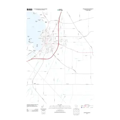
2013 Map of Beaver Dam
USGS Topo · Published 2013About this map
Beaver Dam Lake dominates the northwest corner of this Wisconsin map, its waters punctuated by a cluster of named landforms such as Big Skunk Island, Majestic Island, and Dennings Point. The lake's shoreline reflects recreational and utility development, featuring the Sunset Hills Golf Course and the critical infrastructure of the Beaver Dam Water Works. South of the main settlement area, the landscape transitions into a network of small watercourses including Shaw Brook and Shultz Cr, which feed toward the Beaver Dam River.
Find a feature on this map
116 named features on this map. Tap any name to fly to it.
Don’t see what you’re looking for? This feature index may not catch every label — zoom into the map to look around manually.
Map Details
Editions of this 2013 Beaver Dam Map
This is the sole edition of this map. No revisions or reprints were ever made.
Other maps of this area

1955 · Beaver Dam
USGS Topo · 1:62,500

1955 · Waupun
USGS Topo · 1:62,500

1955 · Fox Lake
USGS Topo · 1:62,500

1955 · Horicon
USGS Topo · 1:62,500

1957 · Madison
USGS Topo · 1:250,000

1960 · Madison
USGS Topo · 1:250,000

1975 · Horicon NW
USGS Topo · 1:24,000

1975 · Beaver Dam NE
USGS Topo · 1:24,000
1975 · Waupun SW
USGS Topo · 1:24,000

1980 · Fond Du Lac
USGS Topo · 1:100,000