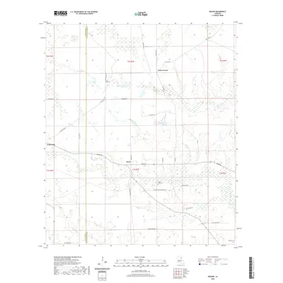
2020 Map of Beaver
USGS Topo · Published 2020About this map
Beaver and the eastern edge of Oakdale anchor this landscape along the boundary of Allen and Evangeline Parishes. The terrain is defined by a dense network of slow-moving waterways and wetlands, including Bayou Marsh, Leger Lake, and Cypress Creek. The transition from the more developed pine-timber lands near Oakdale into the low-lying drainages of Beaver Creek and Morris Branch is reflected in the winding road network, where routes like Beaver Road and Burned Down Road follow the contours of the wet bottomlands.
Find a feature on this map
42 named features on this map. Tap any name to fly to it.
Don’t see what you’re looking for? This feature index may not catch every label — zoom into the map to look around manually.
Map Details
Editions of this 2020 Beaver Map
This is the sole edition of this map. No revisions or reprints were ever made.
Other maps of this area

1935 · Beaver
USGS Topo · 1:31,680

1935 · Pawnee
USGS Topo · 1:31,680

1935 · Oakdale
USGS Topo · 1:31,680

1935 · Turkey Creek
USGS Topo · 1:62,500

1942 · Oakdale
USGS Topo · 1:62,500

1947 · Foley
USGS Topo · 1:31,680

1947 · Bond
USGS Topo · 1:31,680

1949 · Glenmora
USGS Topo · 1:31,680

1949 · Turkey Creek
USGS Topo · 1:62,500
1950 · Foley
USGS Topo · 1:31,680