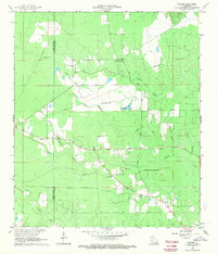
1968 Map of Beaver
USGS Topo · Published 1970About this map
Beaver serves as the focal point of this rural landscape where the border of Allen Parish and Evangeline Parish winds through timbered lowlands. Photogrammetric data from 1966 reveals a network of watercourses including Cypress Creek, Beaver Creek, and the winding Bayou Marsh. The presence of the Beaver Lookout Tower and the nearby Leger Landing Strip indicates the area's mid-century role in forestry management and local aviation. Genealogy-minded researchers will find several local burial sites, such as Pecan Grove Cem, Beaver Cem, and the Detafosse Cem located in the southeastern corner. The terrain is further defined by drainage features like Earnest Gully and Morris Branch, illustrating the complex hydrology of this central Louisiana region before later development. A modern industrial element is introduced by a pipeline that cuts diagonally across the northern sections of the map.
Find a feature on this map
16 named features on this map. Tap any name to fly to it.
Don’t see what you’re looking for? This feature index may not catch every label — zoom into the map to look around manually.
Map Details
Editions of this 1968 Beaver Map
This is the sole edition of this map. No revisions or reprints were ever made.
Other maps of this area

1935 · Beaver
USGS Topo · 1:31,680

1935 · Pawnee
USGS Topo · 1:31,680

1935 · Oakdale
USGS Topo · 1:31,680

1935 · Turkey Creek
USGS Topo · 1:62,500

1942 · Oakdale
USGS Topo · 1:62,500

1947 · Foley
USGS Topo · 1:31,680

1947 · Bond
USGS Topo · 1:31,680

1949 · Glenmora
USGS Topo · 1:31,680

1949 · Turkey Creek
USGS Topo · 1:62,500
1950 · Foley
USGS Topo · 1:31,680