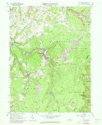
1963 Map of Beaverdale
USGS Topo · Published 1973About this map
The Little Conemaugh River and its tributaries carve through the coal-rich landscape of Cambria County, where industrial operations and residential pockets are densely intertwined. In the early 1960s, the economic character of the region is defined by extensive surface mining, with numerous Strip Mine sites, Mine Dump areas, and a Tipple near Llanfair. The Penn Central railroad network threads through the valleys, connecting the company towns of Beaverdale, Lloydell, and Dunlo.
Find a feature on this map
58 named features on this map. Tap any name to fly to it.
Don’t see what you’re looking for? This feature index may not catch every label — zoom into the map to look around manually.
Map Details
Editions of this 1963 Beaverdale Map
4 editions found
Other maps of this area

1902 · Ebensburg
USGS Topo · 1:62,500

1904 · Ebensburg
USGS Topo · 1:62,500

1904 · Johnstown
USGS Topo · 1:62,500

1907 · Johnstown
USGS Topo · 1:62,500

1908 · Bedford
USGS Topo · 1:62,500

1910 · Bedford
USGS Topo · 1:62,500

1914 · Windber
USGS Topo · 1:62,500

1916 · Windber
USGS Topo · 1:62,500

1944 · Windber
USGS Topo · 1:62,500

1953 · Pittsburgh
USGS Topo · 1:250,000
Featured Places
- Pavia Township, PA
- Portage Township, PA
- Adams Township, PA
- Krayn, Adams Township
- Puritan, Portage Township