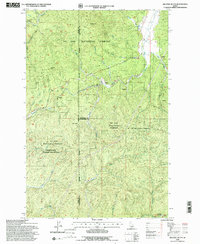
1994 Map of Bechtel Butte
USGS Topo · Published 1997About this map
The St Joe National Forest dominates this landscape in Northern Idaho, where the complex terrain is defined by high points like Bechtel Butte and Sherwin Point. This 1990s revision captures a wilderness area marked by its hydrology, where the St Maries River and its tributaries, such as Cat Spur Creek and Mazie Creek, carve through the forest. The map documents an area of shifting administrative boundaries, notably where the forest is administered by Clearwater National Forest. Along the southern edge, the Potlatch River flows near Badger Meadows, while landmarks like Sherwin and No Name Gulch provide specific points of reference for those tracing the history of land use and forestry in the Panhandle.
Find a feature on this map
29 named features on this map. Tap any name to fly to it.
Don’t see what you’re looking for? This feature index may not catch every label — zoom into the map to look around manually.
Map Details
Editions of this 1994 Bechtel Butte Map
This is the sole edition of this map. No revisions or reprints were ever made.
Other maps of this area

1955 · Pullman
USGS Topo · 1:250,000

1955 · Spokane
USGS Topo · 1:250,000

1958 · Spokane
USGS Topo · 1:250,000

1958 · Pullman
USGS Topo · 1:250,000

1961 · Fernwood
USGS Topo · 1:62,500

1961 · Bovill
USGS Topo · 1:62,500

1969 · Elk River
USGS Topo · 1:24,000

1969 · Anthony Peak
USGS Topo · 1:24,000
1969 · Merry Creek
USGS Topo · 1:24,000

1981 · St Maries
USGS Topo · 1:100,000