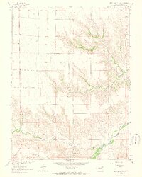
1963 Map of Beecher Island NW
USGS Topo · Published 1965About this map
The Arikaree River basin in Yuma County reveals a landscape shaped by intermittent drainage and the gradual erosion of the High Plains. This 1963 survey captures the area just northwest of the Beecher Island site, showing a network of braided seasonal channels including North Fork Willow Creek, South Fork Willow Creek, and Dry Willow Creek. A single, isolated Grave in section 17 serves as a quiet marker of early pioneer or ranching history on these semi-arid uplands. The terrain is characterized by the divide between the Black Wolf Creek drainage and the larger river system, punctuated by landmarks like Squaw Hill. Human activity is primarily represented by a small-scale industrial Gravel Pit and a sprawling grid of section lines, indicating the persistent influence of the Public Land Survey System on Eastern Colorado's ranching territory.
Find a feature on this map
10 named features on this map. Tap any name to fly to it.
Don’t see what you’re looking for? This feature index may not catch every label — zoom into the map to look around manually.
Map Details
Editions of this 1963 Beecher Island NW Map
3 editions found

Other maps of this area

1954 · Limon
USGS Topo · 1:250,000

1954 · Sterling
USGS Topo · 1:250,000

1957 · Limon
USGS Topo · 1:250,000

1958 · Limon
USGS Topo · 1:250,000

1958 · Sterling
USGS Topo · 1:250,000

1961 · Robb
USGS Topo · 1:24,000

1961 · Laird
USGS Topo · 1:24,000

1961 · Wray
USGS Topo · 1:24,000

1963 · Vernon
USGS Topo · 1:24,000

1963 · Beecher Island
USGS Topo · 1:24,000