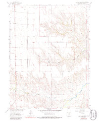
1963 Map of Beecher Island Nw
USGS Topo · Published 1986About this map
The Arikaree River valley defines this Yuma County landscape, recorded during a 1963 survey and photoinspected in 1980 for the development of the Missouri River Basin. The terrain is a complex network of drainage systems, where the North Fork and South Fork converge amidst a dissected plateau. A notable human element on the sheet is a lone Grave located north of the river, a detail of significant value for genealogical research in this sparsely settled region. Evidence of early land use and resource extraction is visible through scattered Well sites and a Gravel Pit near Squaw Hill. The map also traces the winding paths of Black Wolf Creek and Dry Willow Creek, illustrating how the hydrology dictated the local geography long before modern alterations.
Find a feature on this map
9 named features on this map. Tap any name to fly to it.
Don’t see what you’re looking for? This feature index may not catch every label — zoom into the map to look around manually.
Map Details
Editions of this 1963 Beecher Island Nw Map
3 editions found

Other maps of this area

1954 · Limon
USGS Topo · 1:250,000

1954 · Sterling
USGS Topo · 1:250,000

1957 · Limon
USGS Topo · 1:250,000

1958 · Limon
USGS Topo · 1:250,000

1958 · Sterling
USGS Topo · 1:250,000

1961 · Robb
USGS Topo · 1:24,000

1961 · Laird
USGS Topo · 1:24,000

1961 · Wray
USGS Topo · 1:24,000

1963 · Vernon
USGS Topo · 1:24,000

1963 · Beecher Island
USGS Topo · 1:24,000