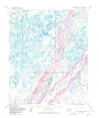
1955 Map of Beechey Point A-3
USGS Topo · Published 1978About this map
Deadhorse serves as the focal point of this arctic industrial landscape, captured during a pivotal era of infrastructure development on the North Slope. The map highlights the braided path of the Sagavanirktok River and its Main Channel, which dominate the eastern half of the sheet with a complex network of gravel bars and shifting watercourses. To the west, the Putuligayuk River meanders through a terrain densely pockmarked by thermokarst lakes and marshy lowlands. The 1975 revisions, shown in purple, document the transformative arrival of The Trans-Alaska Pipeline and the expansion of the Deadhorse Airfield. These additions signify the transition from a remote wilderness to a critical hub for energy extraction, further evidenced by the presence of isolated Oil Wells scattered across the tundra. This survey provides a baseline of the pre-pipeline environment alongside the sudden emergence of the modern oil-support infrastructure.
Find a feature on this map
12 named features on this map. Tap any name to fly to it.
Don’t see what you’re looking for? This feature index may not catch every label — zoom into the map to look around manually.
Map Details
Editions of this 1955 Beechey Point A-3 Map
3 editions found
Other maps of this area

1951 · Beechey Point
USGS Topo · 1:250,000

1951 · Sagavanirktok D-5
USGS Topo · 1:250,000

1955 · Beechey Point
USGS Topo · 1:250,000

1955 · Beechey Point B-2
USGS Topo · 1:63,360

1955 · Beechey Point B-4
USGS Topo · 1:63,360

1955 · Beechey Point A-2
USGS Topo · 1:63,360

1955 · Beechey Point A-3
USGS Topo · 1:63,360

1955 · Beechey Point A-4
USGS Topo · 1:63,360

1955 · Beechey Point B-3
USGS Topo · 1:63,360

1955 · Sagavanirktok D-3
USGS Topo · 1:63,360