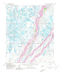
1955 Map of Beechey Point A-3
USGS Topo · Published 1981About this map
Sagavanirktok River dominates this Arctic landscape, its braided channels and vast floodplain recorded during a pivotal era of industrial development on the North Slope. The 1975 revisions highlight the emergence of Deadhorse as a critical infrastructure hub, supporting the early stages of petroleum exploration. This period is most notably marked by the presence of the Trans-Alaska Pipeline (under construction), shown snaking through the tundra alongside the Deadhorse Airfield. The map reveals a complex hydrologic network of thermokarst lakes and smaller streams like the Putuligayuk River, providing a detailed look at the terrain before decades of further industrial expansion. Scattered oil wells across the landscape indicate the beginning of the region's transformation into a major energy-producing frontier, contrasting the stark geography of the Sagavanirktok (Main Channel) River with the arrival of heavy infrastructure.
Find a feature on this map
11 named features on this map. Tap any name to fly to it.
Don’t see what you’re looking for? This feature index may not catch every label — zoom into the map to look around manually.
Map Details
Editions of this 1955 Beechey Point A-3 Map
3 editions found
Other maps of this area

1951 · Beechey Point
USGS Topo · 1:250,000

1951 · Sagavanirktok D-5
USGS Topo · 1:250,000

1955 · Beechey Point
USGS Topo · 1:250,000

1955 · Beechey Point B-2
USGS Topo · 1:63,360

1955 · Beechey Point B-4
USGS Topo · 1:63,360

1955 · Beechey Point A-2
USGS Topo · 1:63,360

1955 · Beechey Point A-3
USGS Topo · 1:63,360

1955 · Beechey Point A-4
USGS Topo · 1:63,360

1955 · Beechey Point B-3
USGS Topo · 1:63,360

1955 · Sagavanirktok D-3
USGS Topo · 1:63,360