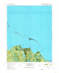
1970 Map of Beechey Point B-3 NW
USGS Topo · Published 1974About this map
Point Storkersen and the surrounding coastline of the Beaufort Sea are captured in this 1970 orthophotomap, documenting early industrial infrastructure along Alaska's North Slope. The landscape is characterized by a network of barrier islands including Return Islands, Egg Island, and Stump Island that shelter Gwydyr Bay from the open sea. This edition reflects the nascent stages of energy development in the region, featuring the Point Mcintyre Landing Strip, a Pumping Station, and the North Prudhoe State 1 site. Settlement patterns are purely industrial or temporary, shown through the Kup Delta Camp and Point Storkersen Camp. Away from the modern infrastructure, the map notes several Cabins (Ruins) and a Winter Trail, signifying the older, more transitory human presence on this tundra before the full-scale arrival of oil industry facilities.
Find a feature on this map
19 named features on this map. Tap any name to fly to it.
Don’t see what you’re looking for? This feature index may not catch every label — zoom into the map to look around manually.
Map Details
Editions of this 1970 Beechey Point B-3 NW Map
3 editions found
Other maps of this area

1951 · Beechey Point
USGS Topo · 1:250,000

1955 · Beechey Point
USGS Topo · 1:250,000
1955 · Beechey Point C-4
USGS Topo · 1:63,360

1955 · Beechey Point B-4
USGS Topo · 1:63,360

1955 · Beechey Point B-3
USGS Topo · 1:63,360

1960 · Beechey Point
USGS Topo · 1:250,000

1962 · Beechey Point B-4
USGS Topo · 1:50,000
1962 · Beechey Point C-4
USGS Topo · 1:50,000

1964 · Beechey Point
USGS Topo · 1:250,000
1970 · Beechey Point B-4 SE
USGS Topo · 1:24,000