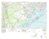
1956 Map of Beeville
USGS Topo · Published 1980About this map
The Guadalupe River and San Antonio River define the complex hydrological landscape of the Texas Coastal Bend, where freshwater systems meet the expansive estuarine waters of San Antonio Bay and Matagorda Bay. This mid-century survey captures a region defined by its energy and defense infrastructure, featuring the sprawling Tom O'Connor Oil Field and the strategic position of Foster AFB near Victoria. The map details the interconnected lagoon system protected by the Matagorda Peninsula and St Joseph Island, including the protected habitats of the Aransas National Wildlife Refuge. Transportation networks of the era are clearly marked, with the Missouri Pacific and Texas and New Orleans railroads facilitating the movement of cattle and oil from inland hubs like Beeville and Goliad to the Gulf ports.
Find a feature on this map
66 named features on this map. Tap any name to fly to it.
Don’t see what you’re looking for? This feature index may not catch every label — zoom into the map to look around manually.
Map Details
Editions of this 1956 Beeville Map
2 editions found

Other maps of this area

1920 · Smiley
USGS Topo · 1:125,000

1920 · Mikeska
USGS Topo · 1:125,000

1920 · San Diego
USGS Topo · 1:62,500

1925 · Oakville No. 4
USGS Topo · 1:48,000

1925 · Mathis No. 2
USGS Topo · 1:48,000

1925 · Robstown
USGS Topo · 1:62,500

1925 · Aransas Pass
USGS Topo · 1:62,500

1925 · Mathis No. 3
USGS Topo · 1:48,000

1925 · Tordia No. 1
USGS Topo · 1:48,000

1925 · Corpus Christi
USGS Topo · 1:62,500