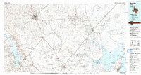
1956 Map of Beeville
USGS Topo · Published 1956This historical map portrays the area of Beeville in 1956, primarily covering Bee County as well as portions of Jackson County, Karnes County, Wharton County, Jim Wells County, Matagorda County, Live Oak County, Aransas County, Victoria, Goliad County, Refugio County, San Patricio County, Calhoun County, and DeWitt County. Featuring a scale of 1:250000, this map provides a highly detailed snapshot of the terrain, roads, buildings, counties, and historical landmarks in the Beeville region at the time. Published in 1956, it is one of 2 known editions of this map due to revisions or reprints.
Find a feature on this map
157 named features on this map. Tap any name to fly to it.
Don’t see what you’re looking for? This feature index may not catch every label — zoom into the map to look around manually.
Map Details
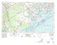
Editions of this 1956 Beeville Map
2 editions found
Historical Maps of River Oaks Number 2 Colonia Through Time
4 maps found