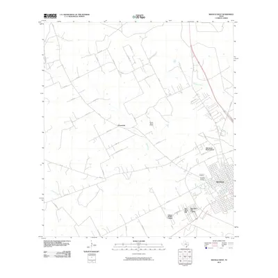
2010 Map of Beeville West
USGS Topo · Published 2010About this map
Beeville sits at the eastern edge of this Bee County survey, revealing the city's western expansion and its proximity to several residential colonias. The landscape is defined by the winding course of Poesta Creek and its tributaries, including Talpacate Creek and Dry Creek, which cut through the agricultural and ranching lands that dominate the region. To the northwest, the small settlement of Orangedale is situated along FM 673, serving as a rural focal point amidst a network of county roads like Co Rd 320.
Find a feature on this map
48 named features on this map. Tap any name to fly to it.
Don’t see what you’re looking for? This feature index may not catch every label — zoom into the map to look around manually.
Map Details
Editions of this 2010 Beeville West Map
This is the sole edition of this map. No revisions or reprints were ever made.
Other maps of this area

1936 · Pettus
USGS Topo · 1:62,500

1953 · Beeville
USGS Topo · 1:250,000

1954 · Skidmore
USGS Topo · 1:62,500

1954 · Fleming
USGS Topo · 1:62,500

1956 · Beeville
USGS Topo · 1:250,000

1956 · Pettus
USGS Topo · 1:62,500

1960 · Beeville
USGS Topo · 1:250,000
1963 · Tuleta
USGS Topo · 1:24,000
1963 · Mineral
USGS Topo · 1:24,000

1963 · Lazy F Ranch
USGS Topo · 1:24,000