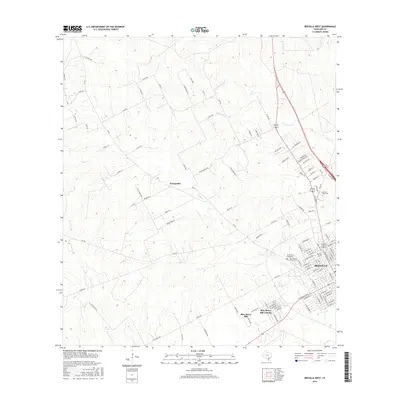
2016 Map of Beeville West
USGS Topo · Published 2016About this map
Beeville anchors the southeast corner of this south Texas landscape, showing the city's western residential expansion and the campus of Coastal Bend Coll. The terrain is defined by the winding paths of Poesta Cr and Talpacate Cr, which carve through the brush country toward the coastal plain. Outside the main city limits, small settlements like Orangedale and the residential clusters of Blue Berry Hill and Blue Berry Hill Colonia illustrate the rural-to-suburban transition occurring in Bee County. For genealogists, the map identifies specific burial grounds including Cementerio Evangelico and Our Lady of Victory Cem. The detailed road network, from the major thoroughfares of FM 673 to named local routes like Red Bird Ridge Dr and Fairway Ridge, provides a precise look at the area's development and property divisions in the mid-2010s.
Find a feature on this map
114 named features on this map. Tap any name to fly to it.
Don’t see what you’re looking for? This feature index may not catch every label — zoom into the map to look around manually.
Map Details
Editions of this 2016 Beeville West Map
This is the sole edition of this map. No revisions or reprints were ever made.
Other maps of this area

1936 · Pettus
USGS Topo · 1:62,500

1953 · Beeville
USGS Topo · 1:250,000

1954 · Skidmore
USGS Topo · 1:62,500

1954 · Fleming
USGS Topo · 1:62,500

1956 · Beeville
USGS Topo · 1:250,000

1956 · Pettus
USGS Topo · 1:62,500

1960 · Beeville
USGS Topo · 1:250,000
1963 · Tuleta
USGS Topo · 1:24,000
1963 · Mineral
USGS Topo · 1:24,000

1963 · Lazy F Ranch
USGS Topo · 1:24,000