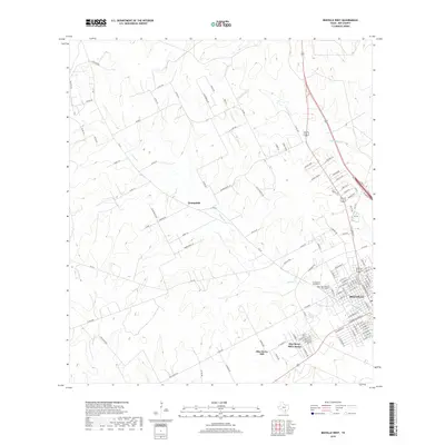
2019 Map of Beeville West
USGS Topo · Published 2019About this map
Beeville anchors the southeastern corner of this South Texas landscape, showing a dense network of residential streets and local landmarks. To the west, the rural community of Orangedale and the residential area of Blue Berry Hill Colonia illustrate the transition from the city center to the surrounding ranchlands. The terrain is defined by low-lying ridges such as Fairway Ridge and Encino Loma, which overlook the winding paths of Poesta Cr and Talpacate Cr. For researchers, the map provides precise locations for the Cementerio Evangelico and Our Lady of Victory Cem, alongside Numerous family-named ranch roads like Algea Ranch Rd and Brown Ranch Ln that trace the historical divisions of the Bee County countryside.
Find a feature on this map
111 named features on this map. Tap any name to fly to it.
Don’t see what you’re looking for? This feature index may not catch every label — zoom into the map to look around manually.
Map Details
Editions of this 2019 Beeville West Map
This is the sole edition of this map. No revisions or reprints were ever made.
Other maps of this area

1936 · Pettus
USGS Topo · 1:62,500

1953 · Beeville
USGS Topo · 1:250,000

1954 · Skidmore
USGS Topo · 1:62,500

1954 · Fleming
USGS Topo · 1:62,500

1956 · Beeville
USGS Topo · 1:250,000

1956 · Pettus
USGS Topo · 1:62,500

1960 · Beeville
USGS Topo · 1:250,000
1963 · Tuleta
USGS Topo · 1:24,000
1963 · Mineral
USGS Topo · 1:24,000

1963 · Lazy F Ranch
USGS Topo · 1:24,000