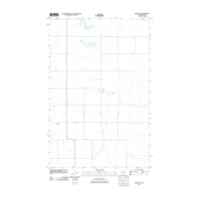
2011 Map of Belden SE
USGS Topo · Published 2011About this map
Finstad Cemetery sits as a solitary historic anchor in this section of Mountrail County, surrounded by the geometric precision of the Great Plains' section-line road system. The landscape is defined by the intersections of gravel routes like 48th St NW and 79th Ave NW, which carve the prairie into regular squares. This 2011 survey reveals a sparsely populated agricultural region, where the primary human footprint is found in the extensive network of local thoroughfares such as 81st Ave NW and 43rd St NW. The drainage patterns and small depressions scattered throughout the quadrangle suggest the classic prairie pothole terrain of North Dakota, where seasonal water shapes the utility of the land between the high-numbered rural avenues.
Find a feature on this map
11 named features on this map. Tap any name to fly to it.
Don’t see what you’re looking for? This feature index may not catch every label — zoom into the map to look around manually.
Map Details
Editions of this 2011 Belden SE Map
This is the sole edition of this map. No revisions or reprints were ever made.
Other maps of this area

1953 · Williston
USGS Topo · 1:250,000

1953 · Watford City
USGS Topo · 1:250,000

1957 · Williston
USGS Topo · 1:250,000

1957 · Watford City
USGS Topo · 1:250,000

1967 · Watford City
USGS Topo · 1:250,000

1981 · Belden SW
USGS Topo · 1:24,000

1981 · New Town
USGS Topo · 1:24,000
1981 · Belden SE
USGS Topo · 1:24,000
1981 · Parshall
USGS Topo · 1:24,000
1981 · Epworth
USGS Topo · 1:24,000