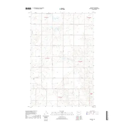
2017 Map of Belden SE
USGS Topo · Published 2017About this map
The rolling plains of New Town, North Dakota, are defined by a precise section-line grid that guides travel across this Mountrail County landscape. At the northern edge of the survey, the Belden Finnish Cem stands as a marker of the area's immigrant heritage and early settlement patterns. Further south, near the intersection of 43rd St NW and 81st Ave NW, lies the Finstad Cem, another vital link for genealogists tracing the families who established homesteads in this portion of the northern plains. The map is heavily structured by these gravel and dirt routes, such as 48th St NW and 79th Ave NW, which carve the prairie into regular townships. The terrain is characterized by numerous small depressions and wetlands common to the Missouri Plateau, creating a complex drainage network that works around the established road grid.
Find a feature on this map
19 named features on this map. Tap any name to fly to it.
Don’t see what you’re looking for? This feature index may not catch every label — zoom into the map to look around manually.
Map Details
Editions of this 2017 Belden SE Map
This is the sole edition of this map. No revisions or reprints were ever made.
Other maps of this area

1953 · Williston
USGS Topo · 1:250,000

1953 · Watford City
USGS Topo · 1:250,000

1957 · Williston
USGS Topo · 1:250,000

1957 · Watford City
USGS Topo · 1:250,000

1967 · Watford City
USGS Topo · 1:250,000

1981 · Belden SW
USGS Topo · 1:24,000

1981 · New Town
USGS Topo · 1:24,000
1981 · Belden SE
USGS Topo · 1:24,000
1981 · Parshall
USGS Topo · 1:24,000
1981 · Epworth
USGS Topo · 1:24,000