1917 Map of Belfast
USGS Topo · Published 1929About this map
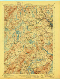
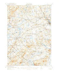
Belfast sits as the regional hub at the mouth of the Passagassawakeag River on Penobscot Bay during this early 20th-century survey. The landscape is characterized by a dense network of crossroads settlements and small-scale industries, including Poors Mill and the Hatcher Mine. The Maine Central railroad tracks follow the river's edge, connecting the coastal port to inland points like City Point and Head of the Tide.
Find a feature on this map
147 named features on this map. Tap any name to fly to it.
Don’t see what you’re looking for? This feature index may not catch every label — zoom into the map to look around manually.
Map Details
Editions of this 1917 Belfast Map
6 editions found

Other maps of this area

1900 · Bucksport
USGS Topo · 1:62,500

1902 · Bucksport
USGS Topo · 1:62,500

1902 · Castine
USGS Topo · 1:62,500

1904 · Castine
USGS Topo · 1:62,500

1904 · Vinalhaven
USGS Topo · 1:62,500

1904 · Rockland
USGS Topo · 1:62,500

1905 · Penobscot Bay
USGS Topo · 1:125,000

1906 · Rockland
USGS Topo · 1:62,500

1913 · Waldoboro
USGS Topo · 1:48,000

1915 · Waldoboro
USGS Topo · 1:62,500