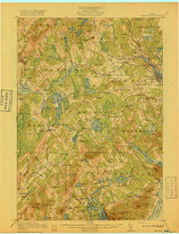
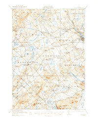
1917 Map of Belfast
USGS Topo · Published 1917About this map
The Passagassawakeag River flows toward the coast of Penobscot Bay, anchoring a landscape defined by small mid-coast Maine hamlets and specialized industry during the early twentieth century. Around the hub of Belfast, the Maine Central RR connects coastal commerce to the interior, passing through City Point and Head of the Tide. The terrain is marked by a dense network of local schools and family-named landmarks, such as the Moody Mountain School and Robinson School, which suggest the social fabric of rural Waldo and Knox counties. Diverse water bodies like Quantabacook Pond and Pitcher Pond are surrounded by prominent peaks including Levenseller Mountain and Hatchet Mtn. This record by the U.S. Geological Survey shows a transitional period where water-powered industry at sites like Poors Mill and Holmes Mill persisted alongside growing rail infrastructure.
Find a feature on this map
155 named features on this map. Tap any name to fly to it.
Don’t see what you’re looking for? This feature index may not catch every label — zoom into the map to look around manually.
Map Details
Editions of this 1917 Belfast Map
6 editions found

Other maps of this area

1900 · Bucksport
USGS Topo · 1:62,500

1902 · Bucksport
USGS Topo · 1:62,500

1902 · Castine
USGS Topo · 1:62,500

1904 · Castine
USGS Topo · 1:62,500

1904 · Vinalhaven
USGS Topo · 1:62,500

1904 · Rockland
USGS Topo · 1:62,500

1905 · Penobscot Bay
USGS Topo · 1:125,000

1906 · Rockland
USGS Topo · 1:62,500

1913 · Waldoboro
USGS Topo · 1:48,000

1915 · Waldoboro
USGS Topo · 1:62,500