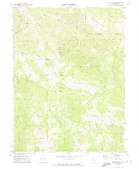
1969 Map of Bell Springs
USGS Topo · Published 1974About this map
Mail Ridge dominates this northern Mendocino County landscape, where the ridges and canyons form a remote network of ranchlands and springs at the end of the 1960s. The small settlement of Bell Springs serves as a central landmark, situated near Bell Springs Mountain and a lone grave that marks the human history of this isolated terrain. The map details the complex drainage systems of Chamise Creek, Island Mountain Creek, and the headwaters of Elkhorn Creek, illustrating the natural barriers that defined local travel and livestock ranching.
Find a feature on this map
31 named features on this map. Tap any name to fly to it.
Don’t see what you’re looking for? This feature index may not catch every label — zoom into the map to look around manually.
Map Details
Editions of this 1969 Bell Springs Map
4 editions found
Other maps of this area

1920 · Cummings
USGS Topo · 1:62,500

1920 · Covelo
USGS Topo · 1:62,500

1920 · Harris
USGS Topo · 1:62,500

1921 · Hoaglin
USGS Topo · 1:62,500

1922 · Island Mountain
USGS Topo · 1:62,500

1931 · Hoaglin
USGS Topo · 1:96,000

1935 · Hoaglin
USGS Topo · 1:125,000

1949 · Alderpoint
USGS Topo · 1:62,500

1951 · Alderpoint
USGS Topo · 1:62,500

1952 · Spyrock
USGS Topo · 1:62,500