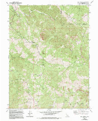
1969 Map of Bell Springs
USGS Topo · Published 1994About this map
Bell Springs sits at the high point of this Mendocino County landscape, surrounded by the steep, convoluted drainage basins of the northern Coast Ranges. The map illustrates a remote ranching and timber environment where the Main Ridge and Trail Ridge dictate the movement of early roads like the Bell Springs Road and Blue Rock Road. Scattered human footprints are visible at the Linger Ranch and several isolated outposts including the Redwine Cabin and Grothe Cabin.
Find a feature on this map
39 named features on this map. Tap any name to fly to it.
Don’t see what you’re looking for? This feature index may not catch every label — zoom into the map to look around manually.
Map Details
Editions of this 1969 Bell Springs Map
4 editions found
Other maps of this area

1920 · Cummings
USGS Topo · 1:62,500

1920 · Covelo
USGS Topo · 1:62,500

1920 · Harris
USGS Topo · 1:62,500

1921 · Hoaglin
USGS Topo · 1:62,500

1922 · Island Mountain
USGS Topo · 1:62,500

1931 · Hoaglin
USGS Topo · 1:96,000

1935 · Hoaglin
USGS Topo · 1:125,000

1949 · Alderpoint
USGS Topo · 1:62,500

1951 · Alderpoint
USGS Topo · 1:62,500

1952 · Spyrock
USGS Topo · 1:62,500