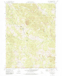
1969 Map of Bell Springs
USGS Topo · Published 1984About this map
Mail Ridge and Island Mountain dominate the topography of this Mendocino County landscape, where deep drainages like Elkhorn Creek and Chamise Creek carve through the steep terrain. The settlement at Bell Springs serves as a focal point for the local backcountry network, flanked by high points like Bell Springs Mountain and the distinctive Camel Rock. Evidence of early habitation and land use is scattered throughout the ridges, from the isolated Redwine Cabin in the south to Linger Ranch and Grothe further north.
Find a feature on this map
35 named features on this map. Tap any name to fly to it.
Don’t see what you’re looking for? This feature index may not catch every label — zoom into the map to look around manually.
Map Details
Editions of this 1969 Bell Springs Map
4 editions found
Other maps of this area

1920 · Cummings
USGS Topo · 1:62,500

1920 · Covelo
USGS Topo · 1:62,500

1920 · Harris
USGS Topo · 1:62,500

1921 · Hoaglin
USGS Topo · 1:62,500

1922 · Island Mountain
USGS Topo · 1:62,500

1931 · Hoaglin
USGS Topo · 1:96,000

1935 · Hoaglin
USGS Topo · 1:125,000

1949 · Alderpoint
USGS Topo · 1:62,500

1951 · Alderpoint
USGS Topo · 1:62,500

1952 · Spyrock
USGS Topo · 1:62,500