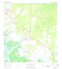
1958 Map of Belle Meade
USGS Topo · Published 1974About this map
Old Marco Junction and the small settlement of Belle Meade anchor this coastal survey, which shows a transition from inland hammocks to the labyrinthine mangroves of the Gulf Coast. The landscape is defined by the winding course of Henderson Creek as it flows into the protected waters of Rookery Bay and Johnson Bay. Near the coast, a lonely Cem on Shell Island offers a point of interest for genealogists and local historians, situated amidst a terrain of tidal marshes and daybeacons.
Find a feature on this map
16 named features on this map. Tap any name to fly to it.
Don’t see what you’re looking for? This feature index may not catch every label — zoom into the map to look around manually.
Map Details
Editions of this 1958 Belle Meade Map
5 editions found
Other maps of this area

1956 · Miami
USGS Topo · 1:250,000

1956 · West Palm Beach
USGS Topo · 1:250,000

1957 · West Palm Beach
USGS Topo · 1:250,000

1958 · West Palm Beach
USGS Topo · 1:250,000

1958 · Miami
USGS Topo · 1:250,000

1958 · Belle Meade
USGS Topo · 1:24,000

1958 · Naples South
USGS Topo · 1:24,000

1958 · Belle Meade NE
USGS Topo · 1:24,000

1958 · Belle Meade NW
USGS Topo · 1:24,000

1958 · Belle Meade SE
USGS Topo · 1:24,000