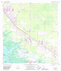
1958 Map of Belle Meade
USGS Topo · Published 1988About this map
Henderson Creek winds through the southwestern coastal wetlands of Collier County, providing a transition from the inland hammocks to the labyrinthine waters of Rookery Bay and Hall Bay. This landscape, surveyed in the late 1950s with late 1980s updates, reveals the early suburban footprints of East Naples and the secluded settlement at Belle Meade. The presence of Old Marco Junction and the nearby Marco Island Airport highlights the region's mid-century shift toward aviation and tourism-driven accessibility.
Find a feature on this map
16 named features on this map. Tap any name to fly to it.
Don’t see what you’re looking for? This feature index may not catch every label — zoom into the map to look around manually.
Map Details
Editions of this 1958 Belle Meade Map
5 editions found
Other maps of this area

1956 · Miami
USGS Topo · 1:250,000

1956 · West Palm Beach
USGS Topo · 1:250,000

1957 · West Palm Beach
USGS Topo · 1:250,000

1958 · West Palm Beach
USGS Topo · 1:250,000

1958 · Miami
USGS Topo · 1:250,000

1958 · Belle Meade
USGS Topo · 1:24,000

1958 · Naples South
USGS Topo · 1:24,000

1958 · Belle Meade NE
USGS Topo · 1:24,000

1958 · Belle Meade NW
USGS Topo · 1:24,000

1958 · Belle Meade SE
USGS Topo · 1:24,000