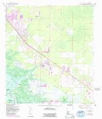
1958 Map of Belle Meade
USGS Topo · Published 1991About this map
Henderson Creek flows through a landscape of mangroves and coastal wetlands toward Rookery Bay and Hall Bay, defining the transition from inland hammock land to the Gulf's edge. The 1958 topography, later updated with bathymetric data, reveals the early infrastructure of East Naples and the localized development at Belle Meade and Rattlesnake Hammock. These small inland nodes were linked by State Roads 41 and 951, which cut through the low-lying terrain to connect the growing Collier County coast.
Find a feature on this map
21 named features on this map. Tap any name to fly to it.
Don’t see what you’re looking for? This feature index may not catch every label — zoom into the map to look around manually.
Map Details
Editions of this 1958 Belle Meade Map
5 editions found
Other maps of this area

1956 · Miami
USGS Topo · 1:250,000

1956 · West Palm Beach
USGS Topo · 1:250,000

1957 · West Palm Beach
USGS Topo · 1:250,000

1958 · West Palm Beach
USGS Topo · 1:250,000

1958 · Miami
USGS Topo · 1:250,000

1958 · Belle Meade
USGS Topo · 1:24,000

1958 · Naples South
USGS Topo · 1:24,000

1958 · Belle Meade NE
USGS Topo · 1:24,000

1958 · Belle Meade NW
USGS Topo · 1:24,000

1958 · Belle Meade SE
USGS Topo · 1:24,000