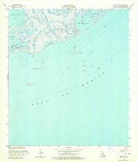
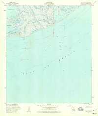
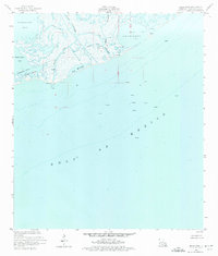
1953 Map of Belle Pass
USGS Topo · Published 1964About this map
The marshy shoreline of Lafourche Parish meets the open water of the Gulf of Mexico in this mid-century coastal survey. Dominating the western edge of the quadrangle is Timbalier Bay, while the central hydrology is defined by the vital outlet of Belle Pass and the winding course of Bayou Lafourche. This period of the Louisiana coast is characterized by an emerging offshore energy economy, evidenced by the numerous oil wells and massive industrial platforms positioned throughout the gulf waters. On shore, infrastructure like the gaging station, a light, and clusters of oil tanks near Bayou Fourchon signal the logistical complexity of the delta. Navigational markers and a submerged pipeline cutting through the estuaries further illustrate the transition of these wetlands into a significant industrial corridor during the early 1950s.
Find a feature on this map
20 named features on this map. Tap any name to fly to it.
Don’t see what you’re looking for? This feature index may not catch every label — zoom into the map to look around manually.
Map Details
Editions of this 1953 Belle Pass Map
4 editions found
Historical Maps of Lafourche Parish Through Time
161 maps found

1892 Cheniere Caminada
Lafourche Parish, LA

1892 Creole
Lafourche Parish, LA

1892 Cut-Off
Lafourche Parish, LA

1892 Lac Des Allemands
Lafourche Parish, LA

1894 Lake Felicity
Lafourche Parish, LA

1894 Timbalier
Lafourche Parish, LA

1932 Houma NE
Lafourche Parish, LA

1932 Houma NW
Lafourche Parish, LA

1932 Houma SE
Lafourche Parish, LA

1932 Lac Des Allemands SE
Lafourche Parish, LA

1932 Lac Des Allemands SW
Lafourche Parish, LA

1932 Thibodaux SE
Lafourche Parish, LA

1935 Bay Courant
Lafourche Parish, LA

1935 Calumet Island
Lafourche Parish, LA

1935 Leeville
Lafourche Parish, LA

1935 Mink Bayou
Lafourche Parish, LA

1935 Pelican Pass
Lafourche Parish, LA

1935 Viguerie Canal
Lafourche Parish, LA

1938 Lafourche
Lafourche Parish, LA

1939 Cut-Off
Lafourche Parish, LA

1939 Lake Felicity
Lafourche Parish, LA

1940 Lafourche
Lafourche Parish, LA

1941 Cut-Off
Lafourche Parish, LA

1941 Lac Des Allemands
Lafourche Parish, LA

1941 Lake Felicity
Lafourche Parish, LA

1944 Lac Des Allemands
Lafourche Parish, LA

1944 Lake Felicity
Lafourche Parish, LA

1945 Leeville
Lafourche Parish, LA

1946 Mink Bayou
Lafourche Parish, LA

1947 Caminada Pass
Lafourche Parish, LA

1949 Bay Dosgris
Lafourche Parish, LA

1949 Bay Tambour
Lafourche Parish, LA

1949 Belle Pass
Lafourche Parish, LA

1950 Golden Meadow Farms
Lafourche Parish, LA

1953 Bay Dosgris
Lafourche Parish, LA

1953 Belle Pass
Lafourche Parish, LA

1953 Calumet Island
Lafourche Parish, LA

1954 Caminada Pass
Lafourche Parish, LA

1954 Golden Meadow Farms
Lafourche Parish, LA

1954 Mink Bayou
Lafourche Parish, LA

1954 Pelican Pass
Lafourche Parish, LA

1956 Bay Tambour
Lafourche Parish, LA

1956 Golden Meadow Farms
Lafourche Parish, LA

1956 Leeville
Lafourche Parish, LA

1956 Pelican Pass
Lafourche Parish, LA

1957 Caminada Pass
Lafourche Parish, LA

1957 Mink Bayou
Lafourche Parish, LA

1962 Bayou Boeuf
Lafourche Parish, LA

1962 Lac Des Allemands
Lafourche Parish, LA

1963 Catahoula Bay
Lafourche Parish, LA

1963 Gheens
Lafourche Parish, LA

1963 Savoie
Lafourche Parish, LA

1964 Bay Courant
Lafourche Parish, LA

1964 Lake Bully Camp
Lafourche Parish, LA

1964 Lake Felicity
Lafourche Parish, LA

1973 Bay L'ours
Lafourche Parish, LA

1994 Bay Courant
Lafourche Parish, LA

1994 Bay Dosgris
Lafourche Parish, LA

1994 Bay Tambour
Lafourche Parish, LA

1994 Belle Pass
Lafourche Parish, LA

1994 Calumet Island
Lafourche Parish, LA

1994 Caminada Pass
Lafourche Parish, LA

1994 Golden Meadow Farms
Lafourche Parish, LA

1994 Lake Bully Camp
Lafourche Parish, LA

1994 Leeville
Lafourche Parish, LA

1994 Mink Bayou
Lafourche Parish, LA

1994 Pelican Pass
Lafourche Parish, LA

1998 Bay Courant
Lafourche Parish, LA

1998 Bay Dosgris
Lafourche Parish, LA

1998 Bay L'Ours
Lafourche Parish, LA

1998 Bayou Boeuf
Lafourche Parish, LA

1998 Belle Pass
Lafourche Parish, LA

1998 Calumet Island
Lafourche Parish, LA

1998 Leeville
Lafourche Parish, LA

1998 Mink Bayou
Lafourche Parish, LA

1998 Pelican Pass
Lafourche Parish, LA

1998 Savoie
Lafourche Parish, LA

2012 Bay Courant
Lafourche Parish, LA

2012 Bay Dosgris
Lafourche Parish, LA

2012 Bay L'Ours
Lafourche Parish, LA

2012 Bayou Boeuf
Lafourche Parish, LA

2012 Bay Tambour
Lafourche Parish, LA

2012 Belle Pass
Lafourche Parish, LA

2012 Calumet Island
Lafourche Parish, LA

2012 Caminada Pass
Lafourche Parish, LA

2012 Catahoula Bay
Lafourche Parish, LA

2012 Gheens
Lafourche Parish, LA

2012 Golden Meadow Farms
Lafourche Parish, LA

2012 Lake Bully Camp
Lafourche Parish, LA

2012 Leeville
Lafourche Parish, LA

2012 Mink Bayou
Lafourche Parish, LA

2012 Pelican Pass
Lafourche Parish, LA

2012 Savoie
Lafourche Parish, LA

2015 Bay Courant
Lafourche Parish, LA

2015 Bay Dosgris
Lafourche Parish, LA

2015 Bay L'Ours
Lafourche Parish, LA

2015 Bayou Boeuf
Lafourche Parish, LA

2015 Bay Tambour
Lafourche Parish, LA

2015 Belle Pass
Lafourche Parish, LA

2015 Calumet Island
Lafourche Parish, LA

2015 Caminada Pass
Lafourche Parish, LA

2015 Catahoula Bay
Lafourche Parish, LA

2015 Gheens
Lafourche Parish, LA

2015 Golden Meadow Farms
Lafourche Parish, LA

2015 Lake Bully Camp
Lafourche Parish, LA

2015 Leeville
Lafourche Parish, LA

2015 Mink Bayou
Lafourche Parish, LA

2015 Pelican Pass
Lafourche Parish, LA

2015 Savoie
Lafourche Parish, LA

2018 Bay Courant
Lafourche Parish, LA

2018 Bay Dosgris
Lafourche Parish, LA

2018 Bay L'Ours
Lafourche Parish, LA

2018 Bayou Boeuf
Lafourche Parish, LA

2018 Bay Tambour
Lafourche Parish, LA

2018 Belle Pass
Lafourche Parish, LA

2018 Calumet Island
Lafourche Parish, LA

2018 Caminada Pass
Lafourche Parish, LA

2018 Catahoula Bay
Lafourche Parish, LA

2018 Gheens
Lafourche Parish, LA

2018 Golden Meadow Farms
Lafourche Parish, LA

2018 Lake Bully Camp
Lafourche Parish, LA

2018 Leeville
Lafourche Parish, LA

2018 Mink Bayou
Lafourche Parish, LA

2018 Pelican Pass
Lafourche Parish, LA

2018 Savoie
Lafourche Parish, LA

2020 Bay Courant
Lafourche Parish, LA

2020 Bay Dosgris
Lafourche Parish, LA

2020 Bay L'Ours
Lafourche Parish, LA

2020 Bayou Boeuf
Lafourche Parish, LA

2020 Bay Tambour
Lafourche Parish, LA

2020 Belle Pass
Lafourche Parish, LA

2020 Calumet Island
Lafourche Parish, LA

2020 Caminada Pass
Lafourche Parish, LA

2020 Gheens
Lafourche Parish, LA

2020 Golden Meadow Farms
Lafourche Parish, LA

2020 Lake Bully Camp
Lafourche Parish, LA

2020 Leeville
Lafourche Parish, LA

2020 Mink Bayou
Lafourche Parish, LA

2020 Pelican Pass
Lafourche Parish, LA

2020 Savoie
Lafourche Parish, LA

2021 Catahoula Bay
Lafourche Parish, LA

2024 Bay Courant
Lafourche Parish, LA

2024 Bay Dosgris
Lafourche Parish, LA

2024 Bay L'Ours
Lafourche Parish, LA

2024 Bayou Boeuf
Lafourche Parish, LA

2024 Bay Tambour
Lafourche Parish, LA

2024 Belle Pass
Lafourche Parish, LA

2024 Calumet Island
Lafourche Parish, LA

2024 Caminada Pass
Lafourche Parish, LA

2024 Catahoula Bay
Lafourche Parish, LA

2024 Gheens
Lafourche Parish, LA

2024 Golden Meadow Farms
Lafourche Parish, LA

2024 Lake Bully Camp
Lafourche Parish, LA

2024 Leeville
Lafourche Parish, LA

2024 Mink Bayou
Lafourche Parish, LA

2024 Pelican Pass
Lafourche Parish, LA

2024 Savoie
Lafourche Parish, LA

2025 Belle Pass
Lafourche Parish, LA

2025 Calumet Island
Lafourche Parish, LA

2025 Caminada Pass
Lafourche Parish, LA

2025 Leeville
Lafourche Parish, LA