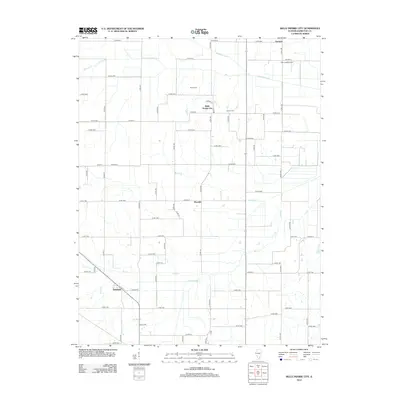
2012 Map of Belle Prairie City
USGS Topo · Published 2012About this map
Belle Prairie City and the surrounding rural landscape of Hamilton County are defined by a grid of agricultural section roads and the natural drainage patterns of the Southern Illinois plains. The settlement of Piopolis sits centrally among these fields, while Delafield occupies the southwestern corner near the intersection of Co Hwy-9 and Co Rd-1650. The area is heavily marked by water management features, including the Kennedy-Voris Main Drain and Auxier Creek Drain, which augment natural waterways like Big Creek and Middle Cr. Genealogists and local historians can locate specific landmarks such as Rawls Cem and Crouch Cem, while the Aden Lookout Tower stands near the northern boundary of Garrison. This survey provides a precise look at the 21st-century road network, from major routes like Co Hwy-20 to the numerous numbered county roads that connect these small rural communities.
Find a feature on this map
68 named features on this map. Tap any name to fly to it.
Don’t see what you’re looking for? This feature index may not catch every label — zoom into the map to look around manually.
Map Details
Editions of this 2012 Belle Prairie City Map
This is the sole edition of this map. No revisions or reprints were ever made.
Other maps of this area

1941 · Enfield
USGS Topo · 1:62,500

1942 · McLeansboro
USGS Topo · 1:62,500

1944 · Enfield
USGS Topo · 1:62,500

1945 · McLeansboro
USGS Topo · 1:62,500

1947 · Wayne City
USGS Topo · 1:62,500

1948 · Fairfield
USGS Topo · 1:62,500

1958 · Belleville
USGS Topo · 1:250,000

1962 · Belleville
USGS Topo · 1:250,000
1971 · Boyleston
USGS Topo · 1:24,000
1973 · Wayne City
USGS Topo · 1:24,000