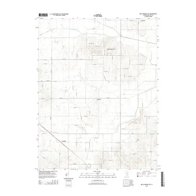
2015 Map of Belle Prairie City
USGS Topo · Published 2015About this map
Belle Prairie City sits amidst a network of agricultural land and drainage systems in northern Hamilton County. This landscape is defined by its rural heritage, anchored by small unincorporated settlements such as Piopolis, Delafield, and Garrison. The map reveals a high concentration of cemeteries including Rawls Cem, Crouch Cem, and Cherry Grove Cem, providing valuable touchpoints for family historians and genealogists tracking early Illinois prairie families. The terrain is largely dictated by water management, with numerous named drainage features like the Auxier Cr Drain, Kennedy-Voris Main Drain, and Dry Island Drain working to redirect surface water from the surrounding fields into natural basins like Big Cr and Opossum Cr. The rectilinear road network, consisting of many county roads like CR-8 and CR-12, connects these remote hamlets across the flat, productive acreage of the Illinois interior.
Find a feature on this map
59 named features on this map. Tap any name to fly to it.
Don’t see what you’re looking for? This feature index may not catch every label — zoom into the map to look around manually.
Map Details
Editions of this 2015 Belle Prairie City Map
This is the sole edition of this map. No revisions or reprints were ever made.
Other maps of this area

1941 · Enfield
USGS Topo · 1:62,500

1942 · McLeansboro
USGS Topo · 1:62,500

1944 · Enfield
USGS Topo · 1:62,500

1945 · McLeansboro
USGS Topo · 1:62,500

1947 · Wayne City
USGS Topo · 1:62,500

1948 · Fairfield
USGS Topo · 1:62,500

1958 · Belleville
USGS Topo · 1:250,000

1962 · Belleville
USGS Topo · 1:250,000
1971 · Boyleston
USGS Topo · 1:24,000
1973 · Wayne City
USGS Topo · 1:24,000