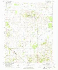
1974 Map of Belle Prairie City
USGS Topo · Published 1977About this map
Belle Prairie City and the surrounding southern Illinois prairie land are documented here in the mid-1970s, showing a landscape defined by small rural settlements and a dense network of country cemeteries. Local family history is preserved through markers like Rawls Cem, Crouch Cem, and Cherry Grove Cem, while the ecclesiastical life of the area is represented by Smith Chapel. The terrain is drained by several prominent watercourses including Auxier Creek, Big Creek, and the curiously named Cabbage Patch Drain.
Find a feature on this map
31 named features on this map. Tap any name to fly to it.
Don’t see what you’re looking for? This feature index may not catch every label — zoom into the map to look around manually.
Map Details
Editions of this 1974 Belle Prairie City Map
This is the sole edition of this map. No revisions or reprints were ever made.
Other maps of this area

1941 · Enfield
USGS Topo · 1:62,500

1942 · McLeansboro
USGS Topo · 1:62,500

1944 · Enfield
USGS Topo · 1:62,500

1945 · McLeansboro
USGS Topo · 1:62,500

1947 · Wayne City
USGS Topo · 1:62,500

1948 · Fairfield
USGS Topo · 1:62,500

1958 · Belleville
USGS Topo · 1:250,000

1962 · Belleville
USGS Topo · 1:250,000
1971 · Boyleston
USGS Topo · 1:24,000
1973 · Wayne City
USGS Topo · 1:24,000