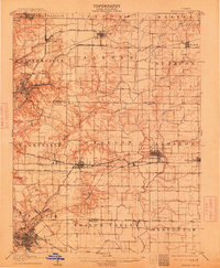
1907 Map of Belleville
USGS Topo · Published 1913About this map
The expanding industrial and transit network of St. Clair and Madison Counties is clearly etched across this early twentieth-century landscape. Belleville serves as the dominant hub in the south, while a dense web of rail infrastructure, including the St Louis and Belleville Electric RR and the Baltimore and Ohio Southwestern RR, connects growing coal and agricultural centers like Collinsville, O'Fallon, and Lebanon. The map reveals the intricate drainage patterns of Silver Creek and its tributaries, such as Little Silver Creek and Mill Creek, which dictated the early placement of settlements and mills.
Find a feature on this map
51 named features on this map. Tap any name to fly to it.
Don’t see what you’re looking for? This feature index may not catch every label — zoom into the map to look around manually.
Map Details
Editions of this 1907 Belleville Map
3 editions found
Other maps of this area

1888 · St. Louis
USGS Topo · 1:62,500

1906 · Breese
USGS Topo · 1:62,500

1907 · Breese
USGS Topo · 1:62,500

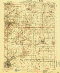
1907 · Belleville
USGS Topo · 1:62,500

1910 · Okawville
USGS Topo · 1:62,500

1910 · Waterloo
USGS Topo · 1:62,500

1912 · New Athens
USGS Topo · 1:62,500

1913 · Waterloo
USGS Topo · 1:62,500

1927 · Alton
USGS Topo · 1:62,500

1927 · Edwardsville
USGS Topo · 1:62,500