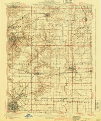
1907 Map of Belleville
USGS Topo · Published 1940About this map
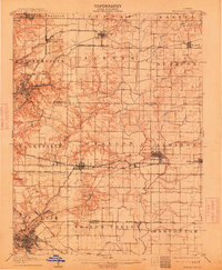
Scott Field stands as a prominent aviation landmark on this topographic survey of Madison and St. Clair counties, reflecting the region's importance just before the mid-century expansion. The landscape is defined by a dense network of early 20th-century transportation, including the St Louis O'Fallon and Lebanon Electric RR and the Vandalia Line. In Belleville and O'Fallon, the grid-patterned growth of these rail-and-road hubs is clearly visible, while smaller settlements like Ridge Prairie and Formosa maintain their rural character. The map meticulously traces the paths of Silver Creek and Loop Creek, showing how the natural drainage shaped the development of Shiloh Valley and the surrounding farmland. For those researching local history, the inclusion of numerous Cem sites and outlying schools provides a detailed look at the social fabric of southwestern Illinois during this era.
Find a feature on this map
52 named features on this map. Tap any name to fly to it.
Don’t see what you’re looking for? This feature index may not catch every label — zoom into the map to look around manually.
Map Details
Editions of this 1907 Belleville Map
3 editions found
Other maps of this area

1888 · St. Louis
USGS Topo · 1:62,500

1906 · Breese
USGS Topo · 1:62,500

1907 · Breese
USGS Topo · 1:62,500

1907 · Belleville
USGS Topo · 1:62,500

1910 · Okawville
USGS Topo · 1:62,500

1910 · Waterloo
USGS Topo · 1:62,500

1912 · New Athens
USGS Topo · 1:62,500

1913 · Waterloo
USGS Topo · 1:62,500

1927 · Alton
USGS Topo · 1:62,500

1927 · Edwardsville
USGS Topo · 1:62,500