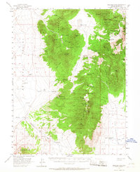
1956 Map of Bellevue Peak
USGS Topo · Published 1968About this map
Mahogany Range and the Spring Creek Range dominate this mid-century Nevada landscape, characterized by isolated mines and vital water sources in an arid terrain. The map records a series of named mining operations, such as the Mountain Boy Mine and the Reese and Berry Mine, scattered among the high peaks and deep canyons like Combe Canyon and Lameroux Canyon. These sites reflect the region's enduring reliance on mineral extraction and the development of the Mountain Boy Range.
Find a feature on this map
57 named features on this map. Tap any name to fly to it.
Don’t see what you’re looking for? This feature index may not catch every label — zoom into the map to look around manually.
Map Details
Editions of this 1956 Bellevue Peak Map
3 editions found
Other maps of this area

1926 · Roberts Mountains
USGS Topo · 1:250,000

1929 · Roberts Mountains
USGS Topo · 1:250,000

1953 · Pinto Summit
USGS Topo · 1:62,500

1953 · Eureka
USGS Topo · 1:62,500

1955 · Millett
USGS Topo · 1:250,000

1956 · Bellevue Peak
USGS Topo · 1:62,500

1956 · Bartine Ranch
USGS Topo · 1:62,500

1956 · Cockalorum Wash
USGS Topo · 1:62,500

1956 · Horse Heaven Mtn
USGS Topo · 1:62,500

1956 · Antelope Peak
USGS Topo · 1:62,500