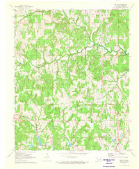
1971 Map of Bellvue
USGS Topo · Published 1973About this map
The small settlement of Bellvue and the surrounding Creek County landscape are defined by the complex water systems of the southern plains. In the early 1970s, the terrain shows a transition toward managed water resources, evidenced by multiple water control structures including the Spillway Elev 864 and the prominent Lake Heyburn at elevation 762. These features intersect with the natural drainage of Polecat Creek and Mosquito Creek, shaping the rural character of the area.
Find a feature on this map
33 named features on this map. Tap any name to fly to it.
Don’t see what you’re looking for? This feature index may not catch every label — zoom into the map to look around manually.
Map Details
Editions of this 1971 Bellvue Map
2 editions found
Other maps of this area

1901 · Nuyaka
USGS Topo · 1:125,000

1912 · Hominy
USGS Topo · 1:125,000

1915 · Hominy
USGS Topo · 1:125,000

1916 · Bristow
USGS Topo · 1:62,500

1929 · Yale
USGS Topo · 1:62,500

1931 · Drumright
USGS Topo · 1:62,500

1932 · Yale
USGS Topo · 1:62,500

1954 · Oklahoma City
USGS Topo · 1:250,000

1955 · Enid
USGS Topo · 1:250,000

1957 · Oklahoma City
USGS Topo · 1:250,000