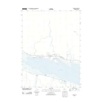
2012 Map of Belmar
USGS Topo · Published 2012About this map
McConaughy Lake dominates this Keith County landscape, serving as a focal point for recreation and local topography. The north shore is particularly developed with seasonal and permanent infrastructure, including the Belmar settlement and several organized camping areas like Omaha Beach Campground and Cedar Vue Campground. The map details the drainage patterns of Otter Creek, which flows south into the reservoir, and Sand Creek to the east. South of the water, the terrain becomes more dramatic with the deep incisions of Eagle Canyon and Coyote Canyon. This 2012 survey illustrates how the local road network, including Petersons and Lakeview W Rd, has been shaped by the presence of the reservoir and its supporting tourism industry, including facilities like the JS Otter Creek Resort and RV Park.
Find a feature on this map
27 named features on this map. Tap any name to fly to it.
Don’t see what you’re looking for? This feature index may not catch every label — zoom into the map to look around manually.
Map Details
Editions of this 2012 Belmar Map
This is the sole edition of this map. No revisions or reprints were ever made.
Other maps of this area

1897 · Ogallala
USGS Topo · 1:125,000

1900 · Chappell
USGS Topo · 1:125,000

1900 · Ogallala
USGS Topo · 1:125,000

1954 · Scottsbluff
USGS Topo · 1:250,000

1954 · North Platte
USGS Topo · 1:250,000

1956 · North Platte
USGS Topo · 1:250,000

1957 · North Platte
USGS Topo · 1:250,000

1958 · Scottsbluff
USGS Topo · 1:250,000

1967 · North Platte
USGS Topo · 1:250,000
1971 · Brule NW
USGS Topo · 1:24,000