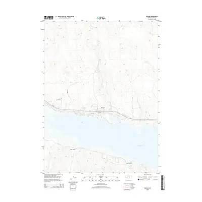
2014 Map of Belmar
USGS Topo · Published 2014About this map
McConaughy Lake dominates the southern landscape of this Keith County region, where the high plains meet the water's edge. The small settlement of Belmar sits north of the reservoir, positioned along the Ne-92 corridor and the local railroad line. The map captures a detailed view of the shoreline developments including Lakeshore and Petersons, showing how residential and recreational growth has shaped the northern bank. Beyond the immediate coast, the terrain is defined by drainages such as Otter Cr and Sand Cr, which flow south toward the lake through a series of depressions and small bodies of water like Smith Lake. To the south of the water, the topography rises sharply into the distinctive breaks of Eagle Canyon and Coyote Canyon, illustrating the dramatic shift in elevation that characterizes the Platte River valley's edge.
Find a feature on this map
14 named features on this map. Tap any name to fly to it.
Don’t see what you’re looking for? This feature index may not catch every label — zoom into the map to look around manually.
Map Details
Editions of this 2014 Belmar Map
This is the sole edition of this map. No revisions or reprints were ever made.
Other maps of this area

1897 · Ogallala
USGS Topo · 1:125,000

1900 · Chappell
USGS Topo · 1:125,000

1900 · Ogallala
USGS Topo · 1:125,000

1954 · Scottsbluff
USGS Topo · 1:250,000

1954 · North Platte
USGS Topo · 1:250,000

1956 · North Platte
USGS Topo · 1:250,000

1957 · North Platte
USGS Topo · 1:250,000

1958 · Scottsbluff
USGS Topo · 1:250,000

1967 · North Platte
USGS Topo · 1:250,000
1971 · Brule NW
USGS Topo · 1:24,000