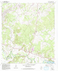
1964 Map of Belmont
USGS Topo · Published 1994About this map
The Guadalupe River snakes through the southern edge of this landscape, its path punctuated by Lake Gonzales and the mouth of Burroughs Cr. This region, split by the Guadalupe and Gonzales county line, is defined by its small farming communities and numerous family or community burial grounds. Settlement patterns are focused around Belmont and the smaller Graves area, where the terrain is marked by winding waterways like Smith Creek and Nash Creek. Rural life is etched into the map through institutions such as St James Ch and Newbirth Ch, alongside several documented cemeteries including Huebotter Cem, Nash Creek Cem, and Harris Chapel Cem. The presence of Gravel Pits and a Sand Pit near the river suggests a local economy tied to the extraction of river-basin resources during this mid-century period.
Find a feature on this map
22 named features on this map. Tap any name to fly to it.
Don’t see what you’re looking for? This feature index may not catch every label — zoom into the map to look around manually.
Map Details
Editions of this 1964 Belmont Map
3 editions found
Other maps of this area

1911 · San Marcos
USGS Topo · 1:125,000

1919 · San Marcos
USGS Topo · 1:125,000

1920 · Smiley
USGS Topo · 1:125,000

1924 · San Marcos 3-d
USGS Topo · 1:48,000

1925 · San Marcos 4-c
USGS Topo · 1:48,000

1925 · San Marcos 4-a
USGS Topo · 1:48,000

1929 · Luling
USGS Topo · 1:62,500

1930 · Seguin
USGS Topo · 1:62,500

1942 · Dewville
USGS Topo · 1:62,500

1953 · Seguin
USGS Topo · 1:250,000