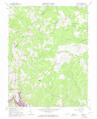
1966 Map of Belmont
USGS Topo · Published 1974About this map
Lake Anna begins its reach into the southern portion of this landscape, reflecting the changing hydrology of the region as these waters submerged older valley terrain. Inland from the shoreline, a network of rural settlements like Belmont, Granite Springs, and Paytes anchors the landscape, connected by historic paths such as Rolling Road and Pamunkey Road. The map documents a dense spiritual and social infrastructure of the mid-20th century, noted by numerous local congregations including Craigs Ch, Fellowship Ch, and Belmont Chapel. The presence of a Tailings Pond near Porters hints at local mineral extraction activities, while a persistent Pipeline and various firebreaks cut through the wooded drainage basins of Robertson Run and Catharpin Run. This survey captures the transition of the Virginia countryside during the expansion of North Anna's water systems.
Find a feature on this map
44 named features on this map. Tap any name to fly to it.
Don’t see what you’re looking for? This feature index may not catch every label — zoom into the map to look around manually.
Map Details
Editions of this 1966 Belmont Map
4 editions found
Other maps of this area

1887 · Spottsylvania
USGS Topo · 1:125,000

1892 · Spottsylvania
USGS Topo · 1:125,000

1942 · Mineral
USGS Topo · 1:31,680

1942 · Lahore
USGS Topo · 1:31,680

1942 · Partlow
USGS Topo · 1:31,680

1942 · Belmont
USGS Topo · 1:31,680

1942 · Contrary Creek
USGS Topo · 1:31,680

1942 · Brokenburg
USGS Topo · 1:31,680

1943 · Chancellorsville
USGS Topo · 1:24,000

1943 · Mine Run
USGS Topo · 1:24,000