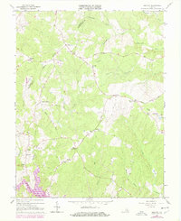
1966 Map of Belmont
USGS Topo · Published 1978About this map
Belmont and its surrounding rural hamlets are mapped here during a period of transition, most notably marked by the development of Lake Anna in the southern portion of the sheet. The landscape is a network of small, family-associated locales like Richards Shop, Mastins Corner, and Porters, connected by historic thoroughfares such as Lawyers Road and Catharpin Road. The presence of numerous rural congregations, including Craigs Ch, Fellowship Ch, and Belmont Chapel, along with various unnamed cemeteries, reflects the deep-rooted social and genealogical fabric of this portion of Orange and Spotsylvania Counties. The topographical record captures the area just as modern infrastructure, such as the prominent north-south Pipeline, began to bisect the established agricultural and timber lands drained by Catharpin Run and Plentiful Creek.
Find a feature on this map
44 named features on this map. Tap any name to fly to it.
Don’t see what you’re looking for? This feature index may not catch every label — zoom into the map to look around manually.
Map Details
Editions of this 1966 Belmont Map
4 editions found
Other maps of this area

1887 · Spottsylvania
USGS Topo · 1:125,000

1892 · Spottsylvania
USGS Topo · 1:125,000

1942 · Mineral
USGS Topo · 1:31,680

1942 · Lahore
USGS Topo · 1:31,680

1942 · Partlow
USGS Topo · 1:31,680

1942 · Belmont
USGS Topo · 1:31,680

1942 · Contrary Creek
USGS Topo · 1:31,680

1942 · Brokenburg
USGS Topo · 1:31,680

1943 · Chancellorsville
USGS Topo · 1:24,000

1943 · Mine Run
USGS Topo · 1:24,000