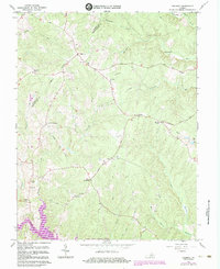
1966 Map of Belmont
USGS Topo · Published 1984About this map
Richards Shop and Paytes anchor the northern landscape of this rural corridor along the Orange and Spotsylvania County line. The map captures a transition in the region's geography, most notably with the creation of Lake Anna in the south, which significantly altered the local drainage of Pamunkey Creek. This 1966 survey, updated with 1983 photorevisions, documents a high density of rural religious life with numerous small congregations like Craigs Ch, True Light Ch, and Belmont Chapel scattered among the wooded hills.
Find a feature on this map
45 named features on this map. Tap any name to fly to it.
Don’t see what you’re looking for? This feature index may not catch every label — zoom into the map to look around manually.
Map Details
Editions of this 1966 Belmont Map
4 editions found
Other maps of this area

1887 · Spottsylvania
USGS Topo · 1:125,000

1892 · Spottsylvania
USGS Topo · 1:125,000

1942 · Mineral
USGS Topo · 1:31,680

1942 · Lahore
USGS Topo · 1:31,680

1942 · Partlow
USGS Topo · 1:31,680

1942 · Belmont
USGS Topo · 1:31,680

1942 · Contrary Creek
USGS Topo · 1:31,680

1942 · Brokenburg
USGS Topo · 1:31,680

1943 · Chancellorsville
USGS Topo · 1:24,000

1943 · Mine Run
USGS Topo · 1:24,000