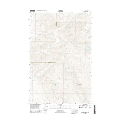
2014 Map of Belmore Sloughs
USGS Topo · Published 2014About this map
Belmore Sloughs and the complex drainage of the Jocko River system dominate this high-altitude landscape along the border of Lake and Missoula counties. The terrain is defined by the convergence of the N Fork Jocko River, Middle Fork Jocko River, and S Fork Jocko River, creating a network of alpine waterways and mountain lakes including White Horse Lake and Meadow Lake. Human impact is limited primarily to primitive transportation routes like Jocko Rd and the Jocko Canyon Rd, which navigate the steep descent through Jocko Canyon. The map reveals a wild hydrological environment where Lower Jocko Lake and numerous creeks like Falls Cr and Deep Cr feed into the larger river basin, illustrating the primary watershed characteristics of this part of the Mission Mountains.
Find a feature on this map
25 named features on this map. Tap any name to fly to it.
Don’t see what you’re looking for? This feature index may not catch every label — zoom into the map to look around manually.
Map Details
Editions of this 2014 Belmore Sloughs Map
This is the sole edition of this map. No revisions or reprints were ever made.
Other maps of this area

1921 · Elbow Lake
USGS Topo · 1:125,000

1955 · Choteau
USGS Topo · 1:250,000

1957 · Choteau
USGS Topo · 1:250,000

1958 · Choteau
USGS Topo · 1:250,000

1962 · Choteau
USGS Topo · 1:250,000

1965 · Upper Jocko Lake
USGS Topo · 1:24,000
1965 · Belmore Sloughs
USGS Topo · 1:24,000
1965 · Gold Creek Peak
USGS Topo · 1:24,000
1965 · Stuart Peak
USGS Topo · 1:24,000

1965 · Gray Wolf Lake
USGS Topo · 1:24,000