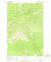
1965 Map of Belmore Sloughs
USGS Topo · Published 1968About this map
The Flathead Indian Reservation encompasses this 1960s landscape, defined by the convergence of the Middle Fork Jocko River and the South Fork Jocko River. The terrain is characterized by steep elevation changes, ranging from the high point at Jocko Lookout down to the water-rich valley floor. Notable aquatic features include the high-altitude White Horse Lake and Meadow Lake, while the namesake Belmore Sloughs occupy the central basin near the Lake Co Missoula Co boundary.
Find a feature on this map
15 named features on this map. Tap any name to fly to it.
Don’t see what you’re looking for? This feature index may not catch every label — zoom into the map to look around manually.
Map Details
Editions of this 1965 Belmore Sloughs Map
2 editions found
Other maps of this area

1921 · Elbow Lake
USGS Topo · 1:125,000

1955 · Choteau
USGS Topo · 1:250,000

1957 · Choteau
USGS Topo · 1:250,000

1958 · Choteau
USGS Topo · 1:250,000

1962 · Choteau
USGS Topo · 1:250,000

1965 · Upper Jocko Lake
USGS Topo · 1:24,000
1965 · Gold Creek Peak
USGS Topo · 1:24,000
1965 · Stuart Peak
USGS Topo · 1:24,000

1965 · Gray Wolf Lake
USGS Topo · 1:24,000

1965 · Lake Marshall
USGS Topo · 1:24,000