
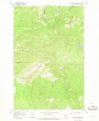
1965 Map of Lake Marshall
USGS Topo · Published 1968About this map
Lindbergh Lake and the surrounding high-country watersheds dominate this mid-1960s survey of the northern Rockies. The landscape is defined by the intersection of administrative and natural boundaries, most notably where the Lolo Indian Reservation Boundary meets the Flathead National Forest and Lolo National Forest. This era of land management is preserved through the network of the Pack Trail system, which provided the primary access for foresters and early recreationists through the Henry Mountains. The drainage patterns are clearly delineated, showing the headwaters of the Swan River and the Clearwater River, along with numerous alpine water bodies such as Lake Marshall and Lake Dinah. The absence of developed roads emphasizes the remote character of this region during the mid-twentieth century, as researchers can trace the historic foot and horse paths that connected West Fork Point to the surrounding basins.
Find a feature on this map
21 named features on this map. Tap any name to fly to it.
Don’t see what you’re looking for? This feature index may not catch every label — zoom into the map to look around manually.
Map Details
Editions of this 1965 Lake Marshall Map
This is the sole edition of this map. No revisions or reprints were ever made.
Other maps of this area

1921 · Elbow Lake
USGS Topo · 1:125,000

1955 · Choteau
USGS Topo · 1:250,000

1957 · Choteau
USGS Topo · 1:250,000

1958 · Choteau
USGS Topo · 1:250,000

1962 · Choteau
USGS Topo · 1:250,000

1965 · Upper Jocko Lake
USGS Topo · 1:24,000
1965 · Belmore Sloughs
USGS Topo · 1:24,000

1965 · Holland Lake
USGS Topo · 1:24,000

1965 · Seeley Lake West
USGS Topo · 1:24,000

1965 · Gray Wolf Lake
USGS Topo · 1:24,000