
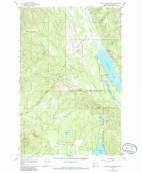
1965 Map of Seeley Lake West
USGS Topo · Published 1968About this map
Seeley Lake and the Clearwater River corridor dominate this mid-century western Montana landscape, reflecting an era defined by forest management and recreation. The Seeley Lake Ranger Station sits as a primary administrative anchor on the eastern shore of the lake, while the Seeley Lake Game Preserve spans the riparian lowlands between the water and the surrounding timberlands. Further south, Placid Lake serves as another focal point for the community, marked by the presence of the Placid Lake Sch nearby.
Find a feature on this map
32 named features on this map. Tap any name to fly to it.
Don’t see what you’re looking for? This feature index may not catch every label — zoom into the map to look around manually.
Map Details
Editions of this 1965 Seeley Lake West Map
2 editions found
Other maps of this area

1902 · Ovando
USGS Topo · 1:125,000

1905 · Ovando
USGS Topo · 1:125,000

1921 · Elbow Lake
USGS Topo · 1:125,000

1955 · Choteau
USGS Topo · 1:250,000

1957 · Choteau
USGS Topo · 1:250,000

1958 · Choteau
USGS Topo · 1:250,000

1962 · Choteau
USGS Topo · 1:250,000

1965 · Upper Jocko Lake
USGS Topo · 1:24,000
1965 · Gold Creek Peak
USGS Topo · 1:24,000
1965 · Seeley Lake East
USGS Topo · 1:24,000