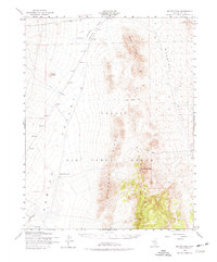
1952 Map of Belted Peak
USGS Topo · Published 1977About this map
Belted Range dominates this landscape in the early 1950s, a period when this high desert terrain was primarily defined by its isolation and specialized military use. The map reveals the extensive Nellis Air Force Range boundary, which encompasses massive geological formations like Lava Ridge and Limestone Ridge. This was an era of intense federal activity in the Nevada desert, though traditional land markers still persisted.
Find a feature on this map
18 named features on this map. Tap any name to fly to it.
Don’t see what you’re looking for? This feature index may not catch every label — zoom into the map to look around manually.
Map Details
Editions of this 1952 Belted Peak Map
3 editions found

Other maps of this area

1908 · Kawich
USGS Topo · 1:250,000

1942 · Emigrant Valley
USGS Topo · 1:125,000

1942 · Reveille Peak
USGS Topo · 1:125,000

1942 · Wheelbarrow Peak
USGS Topo · 1:125,000

1942 · Penoyer Valley
USGS Topo · 1:125,000

1952 · Kawich Peak
USGS Topo · 1:62,500

1952 · Quartzite Mtn
USGS Topo · 1:62,500

1952 · White Blotch Springs
USGS Topo · 1:62,500

1952 · Reveille Peak
USGS Topo · 1:62,500

1952 · Wheelbarrow Peak
USGS Topo · 1:62,500