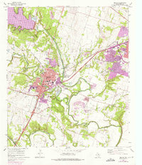
1965 Map of Belton
USGS Topo · Published 1975About this map
The Leon River and Lampasas River converge south of Belton, framing a landscape defined by significant mid-century infrastructure and educational institutions. This era shows the expansion of urban areas in purple tint, particularly around Temple and the southern reaches of Belton, while the northern portion is dominated by the reservoir of Belton Lake and its spillway. The map captures Hardin-Baylor College and local schools like Harris Sch and Tyler Sch, which serve as anchors for the local community.
Find a feature on this map
48 named features on this map. Tap any name to fly to it.
Don’t see what you’re looking for? This feature index may not catch every label — zoom into the map to look around manually.
Map Details
Editions of this 1965 Belton Map
3 editions found
Other maps of this area

1885 · Taylor
USGS Topo · 1:125,000

1887 · Taylor
USGS Topo · 1:125,000

1892 · Temple
USGS Topo · 1:125,000

1893 · Georgetown
USGS Topo · 1:125,000

1894 · Gatesville
USGS Topo · 1:125,000

1894 · Taylor
USGS Topo · 1:125,000

1924 · Gatesville 4-d
USGS Topo · 1:48,000

1924 · Gatesville 4-a
USGS Topo · 1:48,000

1924 · Temple 3-C
USGS Topo · 1:48,000

1924 · Temple 3-B
USGS Topo · 1:48,000