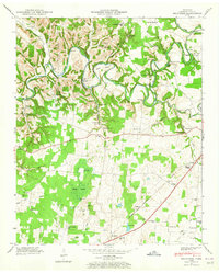
1947 Map of Belvidere
USGS Topo · Published 1965About this map
Elk River winds through this Franklin County landscape, its course marked by numerous bends and river miles from Mile 145 to Mile 159. The terrain is defined by the high ground of Highland Ridge and the broad, low-lying expanse of Mingo Swamp. Settlement patterns in the late 1940s show a decentralized community structure tied together by rural schools like Fairview Sch and numerous country churches, including Mt Zion and Little Hurricane Ch. The industrial footprint of the era is preserved at Owl Hollow Mill, situated along the flume in Owl Hollow.
Find a feature on this map
71 named features on this map. Tap any name to fly to it.
Don’t see what you’re looking for? This feature index may not catch every label — zoom into the map to look around manually.
Map Details
Editions of this 1947 Belvidere Map
4 editions found
Other maps of this area

1928 · Decherd
USGS Topo · 1:62,500

1936 · Cumberland Springs
USGS Topo · 1:24,000

1936 · Beans Creek
USGS Topo · 1:24,000

1936 · Winchester
USGS Topo · 1:24,000

1936 · Huntland
USGS Topo · 1:24,000

1936 · Belvidere
USGS Topo · 1:24,000

1936 · Pitcher Ridge
USGS Topo · 1:24,000

1936 · Camp Peay
USGS Topo · 1:24,000

1936 · Capitol Hill
USGS Topo · 1:24,000

1936 · Lois
USGS Topo · 1:24,000