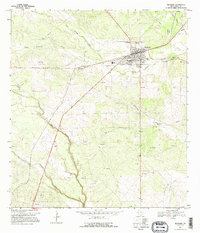
1968 Map of Benavides
USGS Topo · Published 1995About this map
Benavides serves as the central hub of this Duval County landscape, where the confluence of ranching tradition and the burgeoning energy industry of the late 1960s is clearly visible. The town site is concentrated with local landmarks including the High Sch, a Cem, and a Drive-in Theater positioned at the edge of the residential grid. Surrounding the settlement, the terrain is defined by a network of drainage systems like Santa Gertrudis Creek and Agua Poquita Creek, which cut through a landscape increasingly marked by industrial activity.
Find a feature on this map
16 named features on this map. Tap any name to fly to it.
Don’t see what you’re looking for? This feature index may not catch every label — zoom into the map to look around manually.
Map Details
Editions of this 1968 Benavides Map
2 editions found
Other maps of this area

1921 · Falfurrias
USGS Topo · 1:125,000

1956 · Benavides
USGS Topo · 1:62,500

1956 · Laredo
USGS Topo · 1:250,000

1967 · Parrilla Creek SE
USGS Topo · 1:24,000

1967 · Realitos
USGS Topo · 1:24,000

1968 · Concepcion
USGS Topo · 1:24,000

1968 · Benavides NW
USGS Topo · 1:24,000

1968 · San Jose
USGS Topo · 1:24,000

1968 · Benavides
USGS Topo · 1:24,000

1968 · Concepcion NW
USGS Topo · 1:24,000